— UPDATED 26 May 2022 —
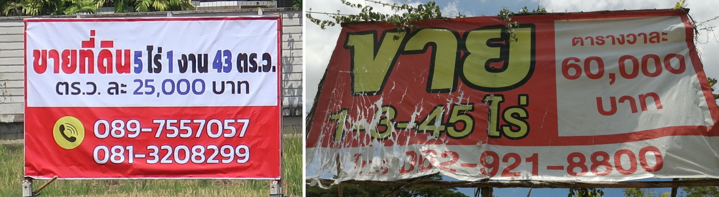 |
| Two plots of land for sale, both plots in different locations but each adjacent to Outer Ring Road #121 |
Photo on the right: This land is located in the southern San Sai District. The sale sign states that the land has an area of 1 rai, 3 ngan and 45 tarang-wa, thus 1.8625 rai, or 745 tarang-wa = 2,980 m². The asking price is 60,000 Baht per tarang-wa, which equals 24 million Baht per rai, so the asking price of the entire land is 44.7 million Baht.
The urban development related to the construction of the Outer Ring Road #121 and its widening in 2019-2020 is briefly described, the probable development due to the new planning of an eastern bypass road is estimated, in particular with regard to the development of the area where Baan Sammi is located. — Die städtebauliche Entwicklung im Zusammenhang mit dem Bau der Outer Ring Road #121 und deren Verbreiterung in den Jahren 2019–2020 wird kurz beschrieben, die voraussichtliche Entwicklung aufgrund der Neuplanung einer östlichen Umgehungsstrasse abgeschätzt, insbesondere im Hinblick auf die bauliche Entwicklung der Gegend, in der sich Baan Sammi befindet.
Along highway-like roads in the eastern area of Chiang Mai, the existing plots were and are of particular interest for commercial use (mainly large shops, company headquarters and large secured residential complexes) due to the land price increase. However, the structural development along these main routes allows conclusions to be drawn about the future development (housing development, housing estate development) in the immediate and wider catchment area of these main routes.
The development along the main routes took place in stages. When the construction of the two-lane eastern section of the Outer Ring Road #121 (with crossings with and without traffic lights) was completed, there were almost exclusively rice fields on both sides of the road and there were hardly any buildings. This was soon followed by a boom in offers for sale of those rice fields which were directly adjacent to the road, evident from the presence of numerous sale signs. Gradually, plots changed ownership, the plots were filled with soil up to street level, and building construction began.
After just a few years, the Outer Ring Road was widened. Two lanes became four, crossings got traffic lights and two same-level crossings were replaced by overpasses or underpasses. After that, you hardly saw any rice fields along the Outer Ring Road, buildings dominated throughout. With the complex and very costly construction of the two-level intersection of the Outer Ring Road #121 with the four-lane Highway #118, the number of buildings also increased along this highway in the direction of Doi Saket and buildings became dominant over rice fields in many sections.
Google.jpg)
The other, much smaller, two-level intersection of Outer Ring Road #121 with the two-lane Rural Road #3013 at the village Ban Tha Rua (บ้านท่ารั้ว) also had and still has a very strong impact on the building development east of the Outer Ring Road in the catchment area of Rural Road #3013. This country road connects Ban Tha Rua, located on Outer Ring Road #121, with Ban Bo Hin (บ้านบ่อหิน), located on Highway #118. Rural Road #3013 also has connecting roads to the more northeastern area where Baan Sammi is located, so the development impact extended to this area as well, but was less significant.
Between the two aforementioned intersections there was another intersection that was downgraded to a T-junction, with the subordinate road allowing left-turn only, when Outer Ring Road #121 became four lanes with a planted continuous median strip: T-junction of Outer Ring Road #121 with Phaya Sirirat Phakdi Alley (ซอย พญาศิริรัตน์ภักดี) in the village Ban Pa Khui (บ้านป่าขุย). This T-junction only affects the building development of the nearby village of Ban Pa Khui.
A field trip was undertaken on 14 May 2022 along Highway #118 and Outer Ring Road #121 to obtain an assessment of current plot availability. The number of offers can be estimated by the number of sale signs on the rice fields. In the early days you saw numerous rice fields and most of them with a sale sign, but now you hardly find any rice fields and only a few of them with a sale sign. It can be assumed that those rice fields without a sale sign either already belong to a new owner for investment, or that the old owner no longer feels it necessary to find a buyer for his remaining rice field due to the profitable sale of his other properties. This assumption is reasonable given the development of property prices along these routes that has been realized so far. It is quite rare to see an asking price revealed on sale signs for vacant land along such routes. Only two signs with prices were seen. These signs listed the asking prices per rai as 10 million and 24 million Baht.
For the assessment of the current land purchase offer along these routes, we have limited ourselves to large properties that border directly on the road, are therefore correspondingly expensive and only suitable for commercial use. Only plots of sizes larger than 1 rai were recorded, and photos of the sale signs are shown in the album Land Sale Offers (1). These were only 8 plots with a sale sign along either side of #118 (10.4 km = 6.5 mi), and only 10 plots with a sale sign along either side of #121 (17.3 km = 10.8 mi). Of course, a very large number of other sale signs were to be seen along these routes. Most of these signs contained offers of building plots in the catchment area of the routes, accessible via side roads. Developed plots were also offered, mostly newly constructed houses and mostly in large gated residential complexes. Most signs listing vacant plots will list the plot size and asking price, but almost all house sales will list the property price or price range, but not the (often tiny) plot size. Signs offering land or houses for rent (or both, buy or rent) are also present, but signs offering only purchase predominate.
The development so far in the catchment area of these two routes, #118 and #121, strongly indicates that the structural development in the catchment area of the planned bypass road will be similar. The route of the new bypass is planned east of Outer Ring Road #121. At a distance of 700–1,000 m from the planned bypass is Baan Sammi located. The effects of this bypass plan can be clearly seen even before it is implemented: numerous rice fields in the area of the planned bypass road have been converted into building plots and offered for sale.
Entlang autobahnähnlicher Straßen im östlichen Bereich von Chiang Mai waren und sind die Grundstücke aufgrund des Preisanstiegs vor allem für gewerbliche Nutzungen (hauptsächlich Gewerbebetriebe und große umgrenzte Wohnanlagen) interessant. Die bauliche Entwicklung entlang dieser Hauptrouten lässt jedoch Rückschlüsse auf die zukünftige Entwicklung (Wohnbebauung, Siedlungsentwicklung) im näheren und weiteren Einzugsbereich dieser Hauptrouten zu.
Die Entwicklung entlang der Hauptrouten erfolgte in Etappen. Bei Baufertigstellung des durchwegs zweispurigen östlichen Abschnitts der Outer Ring Road #121 (mit Kreuzungen mit und ohne Ampelanlagen) lagen beiderseits der Strasse fast ausschliesslich Reisfelder und es war kaum eine Bebauung vorhanden. Bald darauf folgte ein Boom an Verkaufsangeboten der direkt an die Strasse angrenzenden Reisfelder, erkennbar an zahlreichen Verkaufsschildern. Nach und nach wechselten Grundstücke den Eigentümer, die Grundstücke wurden mit Erde bis auf Strassen-Niveau aufgefuellt, und die Bebauung nahm ihren Anfang.
Schon nach wenigen Jahren erfolgte die Verbreiterung der Outer Ring Road. Aus zwei Fahrspuren wurden vier, Kreuzungen bekamen Ampeln und zwei niveaugleiche Kreuzungen wurden ersetzt durch Überführungen oder Unterführungen. Danach sah man entlang der Outer Ring Road kaum noch Reisfelder, die Bebauung dominierte durchwegs. Mit dem sehr aufwändigen und kostenintensiven Bau der zweistöckigen Kreuzung der Outer Ring Road #121 mit der vierspurigen Highway #118 nahm auch entlang dieser Highway in Richtung Doi Saket die Bebauung zu und wurde in vielen Abschnitten gegenüber Reisfeldern dominant.
Die andere, viel kleinere zweistöckige Kreuzung der Outer Ring Road #121 mit der zweispurigen Rural Road #3013 beim Dorf Ban Tha Rua (บ้านท่ารั้ว) hatte und hat auch Jahre spaeter ebenfalls einen sehr starken Einfluss auf die östliche Bebauung der Outer Ring Road im Einzugsgebiet der Rural Road #3013. Diese Landstraße verbindet Ban Tha Rua, gelegen an der Outer Ring Road #121, mit Ban Bo Hin (บ้านบ่อหิน), gelegen am Highway #118. Diese Landstraße hat auch Verbindungsstraßen zum nordöstlicheren Gebiet, in dem sich Baan Sammi befindet, daher erstreckte sich der Einfluss der Bebauung auch auf dieses Gebiet, war aber weniger stark.
Zwischen den beiden oben genannten Kreuzungen gab es eine weitere Kreuzung, die zu einer Zufahrt herabgestuft wurde, wobei die untergeordnete Straße nur Linksabbiegen erlaubte, als die Outer Ring Road #121 vierspurig mit einem bepflanzten durchgehenden Mittelstreifen umgebaut wurde: Zufahrt der Outer Ring Road #121 in die Phaya Sirirat Phakdi Alley (ซอย พญาศิริรัตน์ภักดี) im Dorf Ban Pa Khui (บ้านป่าขุย). Diese Zufahrt hat nur positiven Einfluss auf die Bebauung des nahe gelegenen Dorfes Ban Pa Khui.
Ein Ausflug am 14. Mai 2022 entlang der Highway #118 und der Outer Ring Road #121 wurde unternommen, um eine Einschätzung der aktuellen Grundstücksverfügbarkeit zu bekommen. Die Anzahl der Angebote lässt sich anhand der Verkaufsschilder auf den Reisfeldern abschätzen. Sah man in der Anfangszeit zahlreiche Reisfelder und die Mehrzahl mit einem Verkaufsschild, so findet man jetzt kaum noch Reisfelder und nur noch einige wenige davon mit einem Verkaufsschild. Von den Reisfeldern ohne Verkaufsschild ist anzunehmen, dass sie entweder als Investment bereits einem neuen Eigentümer gehören, oder dass der alte Eigentümer aufgrund des profitablen Verkaufs seiner anderen Grundstücke keine Notwendigkeit mehr sieht, einen Käufer für sein verbliebenes Reisfeld zu finden. Bei der bislang realisierten Grundstückspreisentwicklung entlang dieser Routen liegt diese Vermutung nahe. Es ist ziemlich selten, dass auf Verkaufsschildern für unbebautes Land entlang solcher Routen eine Preisangabe angezeigt wird. Nur zwei Schilder mit Preisen wurden gesehen. Auf diesen Schildern wurden die geforderten Preise pro Rai mit 10 Millionen und 24 Millionen Baht angegeben.
Für die Einschätzung des aktuellen Grundstücksangebots entlang dieser Trassen haben wir uns auf große Grundstücke beschränkt, die direkt an die Strasse grenzen, somit entsprechend teuer und nur für eine gewerbliche Nutzung geeignet sind. Nur Grundstücke grösser als 1 Rai Fläche wurden erfasst, und Fotos der Verkaufsschilder werden im Album Land Sale Offers (1) gezeigt. Es fanden sich beiderseits entlang der #118 (10.4 km = 6.5 mi) nur 8 Grundstücke mit Verkaufsschildern, und beiderseits entlang des östlichen Abschnitts der #121 (17.3 km = 10.8 mi) nur 10 Grundstücke mit Verkaufsschildern. Selbstverständlich waren entlang dieser Routen eine überaus grosse Anzahl weiterer Verkaufsschilder zu sehen. Diese allermeisten Schilder enthielten Angebote von Baugrundstücken im Einzugsbereich der Routen, erreichbar über Nebenstrassen. Auch bebaute Grundstücke wurden angeboten, meist neu errichtete Häuser und meist in grossen bewachten Wohnanlagen. Auf den meisten Schildern, die unbebaute Grundstücke anbieten, sind Grundstücksfläche und Angebotspreis angegeben, hingegen bei fast allen Hauskauf-Angeboten sind die Preise oder die Preisspanne angegeben, nicht aber die (oft winzige) Grundstücksfläche. Auch Schilder, die Grundstücke oder Häuser zum Mieten anbieten (oder alternativ Kauf und Miete) sind vorhanden, jedoch überwiegen Schilder, die nur einen Kauf anbieten.
Die bisherige Entwicklung im Einzugsbereich dieser beiden Routen, #118 und #121, deutet stark darauf hin, dass die bauliche Entwicklung im Einzugsbereich der geplanten Umgehungsstrasse ähnlich verlaufen wird. Die neue Umgehungsstrasse soll östlich der Outer Ring Road #121 verlaufen. In einer Entfernung von 700 bis 1.000 m von der geplanten Umgehungsstrasse liegt Baan Sammi. Die Auswirkungen dieser Planung sind bereits vor ihrer Realisierung deutlich erkennbar: Zahlreiche Reisfelder im Bereich der geplanten Umgehungsstrasse wurden in Baugrundstücke umgewandelt und zum Verkauf angeboten.
.jpg) |
| Google Maps, Chiang Mai area: Portions of Outer Ring Road #121 and Highway #118 are highlighted in yellow. These yellow portions indicate the area that was examined. Baan Sammi is marked on the map on the right. More photos are in the album "Land Sale Offers (1) …" |